17.66.040 Development plan requirements.
The following, as applicable, shall be shown on all development plans associated with planned commercial developments, planned unit developments, conditional use permits, tentative tracts, site plan reviews, and applications for single-family dwellings not already reviewed as part of parcel maps or tentative tracts:
A. Topography.
B. Access road width and percent of grade.
C. Landscape and vegetation details.
D. Structure location.
E. Overhead utilities.
F. Building occupancy class.
G. Type of ignition-resistant construction of structure.
H. Roof classification of buildings.
I. Water supply system.
J. Fuel loading and model, available from city fire department, and data to verify classification of fire-resistive vegetation.
K. Proposed sewers.
L. Drainage concept plan.
M. As deemed appropriate by the city, at the time an applicant applies for a tentative map, conditional use permit, site plan review, general plan amendment, zone change or grading plan approval, the applicant shall submit the following:
1. A site or plot plan drawn to scale of one inch equals one hundred feet or larger, reflecting the proposed project, including property lines and recorded and proposed easements, private roads, public rights-of-way, and pad elevation of all lots;
2. A topographic map of the project site which shall also extend off-site a minimum of three hundred feet in distance unless a greater distance is required by the city engineer to incorporate the topography of all abutting properties as it relates to project site. The map shall be drawn at the same scale as the site plan and shall be based on contour intervals no greater than ten feet except where steep terrain warrants a greater contour interval as approved by the planning director;
3. A slope map of the property depicting natural slope categories of ten, fifteen, twenty, thirty and forty percent and over with contour lines shown;
4. A preliminary grading plan prepared by a registered civil engineer which includes the height and width of all manufactured slopes, proposed retaining wall locations and heights, proposed drainage patterns, methods of storm water retention/detention and identification of areas that will remain in a natural state. Off-site contours for adjacent, unimproved areas within three hundred feet of the project’s boundaries shall be depicted. If the adjacent property is improved, pad elevations, street grades, wall sections and any approved or existing improvements shall be shown. Cross sections will also be required from primary and secondary viewsheds;
5. No less than two cross sections (number to be determined by the planning director) which completely traverse the property at appropriately spaced intervals in locations where topographic variation is the greatest shall be prepared by a registered civil engineer. The cross sections shall clearly depict the vertical variation between natural and finished grade and shall extend three hundred feet beyond the project boundaries;
6. A slope erosion control/revegetation plan shall be provided with all subdivision applications, site plans and grading plans and shall incorporate the provisions of Section 17.66.155, Landscaping;
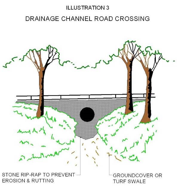
7. In instances where roads cross or traverse natural drainage courses, design shall include natural materials and bank protection (Illustration 3). Design treatment shall be described or diagrammed on plans submitted;
8. If required for fire safety, additional information on the plan beyond the property lines related to slopes, vegetation, fuel breaks, water supply systems and access ways (driveways, secondary access, etc.) shall be shown to the satisfaction of the fire chief.
N. In addition, the planning director, building director or city engineer may require submittal of any or all of the following:
1. A geotechnical report which shall contain, but not be limited to, data regarding the nature, distribution and strengths of existing soils, conclusions and recommendations for grading procedures, design criteria for any identified corrective measures and opinions and recommendations covering the adequacy of sites to be developed. This investigation and report shall be performed by a professional civil engineer who is experienced in the practice of soil mechanics and who is registered with the state of California. Where the site includes slopes exceeding 2:1, the geotechnical report shall include a slope stability analysis. If the proposed development is in an area of concern, the report shall include the method and criteria for mitigation of slope instability.
2. A geology report which shall include, but not be limited to, the surface and subsurface geology of the site, degree of seismic hazard, conclusions and recommendations regarding the effect of geologic conditions on the proposed development, opinions and recommendations covering the adequacy of the sites to be developed, the potential of slope failure within or adjacent to the site and design criteria to mitigate any identified geologic hazards. This investigation and report shall be completed by a certified engineering geologist who is experienced in the practice of engineering geology and who is registered with the state of California.
3. A drainage concept report which shall include, but not be limited to, the hydrologic conditions on the site, possible flood inundation, downstream flood hazards, natural drainage courses, conclusions and recommendations regarding the effect of hydrologic conditions on the proposed development, opinions and recommendations covering the adequacy of the sites to be developed, and design criteria to mitigate any identified hydrologic hazards consistent with these regulations. This report shall account for all runoff and debris from tributary areas and shall provide consideration for each lot or dwelling unit site in a proposed development project. The report shall also take into account all pre- and post-developed flows and shall provide evidence that the proposed project will not burden adjacent and/or downstream properties with flows and/or velocities in excess of the pre-development condition. The report will examine the effects of drainage patterns on the erosion potential that could cause damage to planned or existing structures and ensure that no drainage that could cause erosion will be directed to slope faces. In addition, the drainage concept report shall show the construction phasing for the project and shall show how the drainage through or around the project will be handled on an interim basis, including any proposed temporary facilities. This investigation and report shall be completed by a registered civil engineer experienced in the science of hydrology and hydrologic investigation. The drainage concept report is subject to the review and approval of the city engineer.
4. A computer generated three-dimensional graphic representation of the project site may be required if deemed necessary for reason of clarity.
O. Areas identified as slope protection areas shall be identified as lettered nonbuildable lots on subdivision maps.
P. Structures shall be set back from the top of slopes a distance which is consistent with the following:
1. Determined to possess an adequate factor of safety, as determined by the findings of a geotechnical report required in subsection (N)(1) of this section and approved by the city; and
2. If the site is an area identified as a visual resource area, structures shall meet the visibility criteria as established by an identified primary or secondary viewshed;
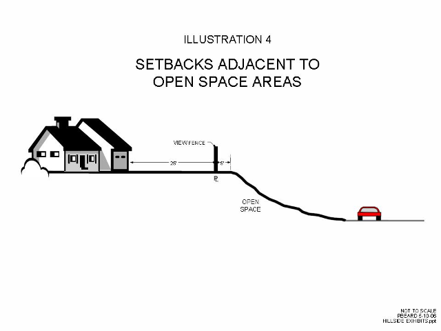
3. On buildable lots placed at the top of manufactured or natural slopes adjacent to parks or open space, the minimum rear yard setback for above ground structures shall be twenty-five feet unless greater setback is required pursuant to this ordinance or for public health, safety or welfare (Illustration 4);
4. The planning commission may allow a lesser setback at a public hearing associated with a subdivision if it can be shown to the satisfaction of the city that alternative methods of viewshed protection such as mounding, landscaping, etc., can provide for an equivalent solution to the protection of the viewshed. Sight line distance and cross section analysis or other methodologies that provide a true representation of alternative viewshed protection methods will be required to determine the adequacy of alternative viewshed protection methods. No setback shall be reduced, regardless of any alternative presented, that does not provide an adequate setback as provided in subsection (P)(1) of this section, or as may otherwise potentially endanger the public health, safety or welfare.
Q. To encourage consistent maintenance of slopes for erosion control and aesthetics, property lines are to be placed at the top of manufactured or natural slopes to be left as open space, park area or natural state and shall be located a minimum of five feet back from the top of the slope (Illustration 4). Additional setback may be required for fire safety or to accommodate trails consistent with an adopted trails plan. (Ord. 4391 § 1 (Exh. A), 2006)